TFT Gps custom routes

Gr8adv

Well-known member
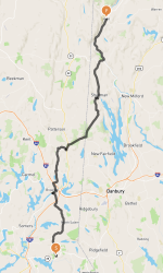
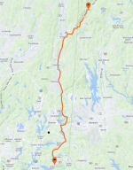
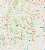
I have always enjoyed BMW’s association with Garmin. When I travel I almost never go the way a gps would take me. I create custom routes on cool roads and to places with BaseCamp and load it onto the gps. Can you do this with new bmw tft and BMW gps mapping?

Thanks.
 
Yes. Not as straightforward as Basecamp to a Garmin device, though.

What works for me is exporting the route (File Export Selection) to a OneDrive folder, opening the OneDrive app on the phone, selecting the GPX file with the route -- which opens the Motorrad Connected app so the route can be imported.

Somewhat similar process, in reverse, for getting tracklogs into Basecamp.
 
When imported does the phone then still need to be connected for the TFT screen to display…play the route? Though not an isssue for some I keep reading about phone disconnect issues users are experiencing.

Guessing the Motorrad Connected app must always be running and phone connected. Which would mean that pretty TFT screen has no way of importing route data and use it without the app running and phone connected. In in which case it is simply a pretty screen though otherwise dumb for maps save for some bike metrics that it displays, bike settings it can change and radio use. Though maybe the TFT can play usb stick mp3 files.

I have never used map routes on my 2019 wing so apology for lack of knowledge on this topic. On the wing i read the company honda went with for navigation was a ‘on off’…as in not good. That plus my days of riding to national rallies in places such as NY are long over so get by without using things like Basecamp and route importing on the Wing.

Still slatted to get a base R18FE though do wonder about options for use on a Bagger model if dealer would let me change to one. But if the motorrad disconnect issues will be a ‘never resolved’ bmw thing that removes a lot of the TFT benefits in my book. Heck, even the less then great new gen wings can do maps without a phone (aka phone discount issue in the case of bmw).
 
Last edited:
Importing routes to the phone does NOT require a connected bike. You can do the whole thing with just the phone. Near as I can tell, the phone does it all and the bike's TFT is just an alternate display. (Always find it funny when I tell the phone to "Go" on a route then it tells me to connect a motorcycle -- as if were merely a dongle.)

The only beyond-words-frustrating irritation is the audible turn-by-turn directions. Sometimes they play, sometimes they don't. Can't find a setting on the bike or phone that reliably works. They come and go randomly. I'll turn they bike off trying to get them. Never seems to work. Then a gas stop (with bathroom break) gets them going. Or stops them if they were going. And sometimes puts them to the speakers rather than my headset. Only reliable indicator is the words "RADIO OFF" on the bottom of the display always mean the directions are off. (Not that tbey are on when the words are not displayed. Random.) Know my firmware is behind. Only 1,500 miles from a service interval so waiting seems practical.
So no gps/mapping out of cell range? Out west that is a game changer.

On a side note I have the on/off voice issue with my phone as well. Not sure it’s a bmw thing but IDK.
 
Last edited:
While talking to a sales rep at a dealer he said something along the lines of (I may have written it down wrong)...
turn off verval gps commands on backside of iphone.

Not certain what that means nor where such settings are. Seems he knows a tech nerd guy that dives deep into such stuff and that is what he told the sales rep.
I suspect there is a specific sequence for the rider to do to making this all work seamlessly. Due to the number of phones avail likely no one set of instructions will work.

But general guidelines like Turning off voice commands, making sure your phone is set to not time out etc would be helpful to solving many of the apparent glitches.

My dealer is working towards something they can publish. When I see it I will pass it on.
The dealers must be tossing their hands up in the air hoping/waiting for BMW to address those customer concerns...
 
So no gps/mapping out of cell range? Out west that is a game changer.

On a side note I have the on/off voice issue with my phone as well. Not sure it’s a bmw thing but IDK.
The Connected maps download to the phone, and will work without a signal or even if you turn off cell data. I’ve been in several areas with no signal (west coast), and the nav worked fine.
 
Well, that is good news. Does the app BMW use allow for…think it is called ‘way’ points? Places you wanna stop along the way in a route?

Maybe it was just on Goldwing but I kept reading about, on that bike, either not being able to see them or skip one along a route to continue your GPS navigation or in this case…the bmw…download map.
Thank you
Yes, Connected allows for multiple waypoints, and you can skip them while on your route.

I’m getting more familiar with using Connected and exporting routes from Basecamp as a GPX file.

Creating a route with waypoints in Connected is a bit fussy due to the limitations of screen size and sometimes searching for a point of interest- a park, for instance- will come back either unfound or will try and drop you in the middle of the park as opposed to the park entrance/parking lot. Great for GS owners!

I also have a current ticket open with BMW because sometimes entering an address or POI will return a result that is nowhere near the actual address/location. This has happened to me a couple times, so when I do route through Connected, I always verify the location with Google.

When you use Basecamp (I have a Garmin for my previous bike) to create a route and export the GPX, Connected will import it as a Track, or a list of waypoints, or both. I have found that every time I have imported waypoints, they never import in the order I built the route and I have to reorder them in the Connected app, which isn’t super easy - again due to doing something on a phone screen.
 
Clarification: Cell service is NOT required. The Connected app requires downloading maps and storing them in the phone. Navigation is tracked against these saved maps. I have logged many miles without cell service -- including over the past weekend -- and had no issues with navigation or the ensuing track logs.

There are some issues getting the app and the bike working together when cell service or WiFi are unavailable and the phone is NOT in the last known location. With the phone stored in the bike's compartment (necessary to keep it charging but not a requirement for navigating), a stop is required if the phone doesn't sort things out before prompting a retry request. Minor issue but unknown to GPS users.

After using Garmin units for decades, some of the differences imposed by the Connected app are head scratchers but the app seems to work just as well at the things that count.

Except for the turn-by-turn audible instructions. The phone has settings. The bike has settings. Instructions are ridiculously inadequate. And no combination of settings produces consistent results. Hoping that upgraded firmware for the bike fixes that.
 
The issue with Connected re-arranging the order of waypoints is NOT one I have encountered. My Basecamp-generated GPX files get imported as routes and Connected gets them right -- though it may calculate a different route between waypoints than anticipated. (Garmin does that, too.) Import process allows me two versions -- one with only start and end points, the other with oodles (many more than was defined in Basecamp) of waypoints. Always pick the oodles so have no idea how the 2-waypoint file works.

Otherwise, I agree with everything B O Q R 18 B posted.

Navigating to a specific point/place works well but getting places into Connected isn't easy and the downloaded maps don't always have the places in the correct spot. Not really an impressive app for a Garmin user. But functional.

Edited to add: My phone is Android. Galaxy S10e. Apple certainly works differently. Likely different versions of Android, too. Basics are the same but terminology and sequence of steps may vary.
 
Lordy…the mothership BMW needs to publish a step by step guide for both apple and android phones. That is, once they get their beep beep together, so their Motorrad Connected app works without issues.
Mean time it is what it is and users are sorting it out bit by bit I see.
Thanks all
 
I use the BMW Motorrad Connected app all the time while riding (R 18 B Model): Streaming Music, Navigation and or Recording Trips that we have taken. I started using the Harley-Davidson Ride Planner to Import my recorded trips, as well as the Export function to load in Edited Recorded Trips or Existing Trips back into the BMW Motorrad Connected app; I found this site to be extremely easy to use.

On another but similar topic: I thought it would be cool if the FORUM site had an area where other users could upload routes and such to be shared; I started a new thread, however the FORUM site didn't allow *.GPX file extensions?

Thoughts ... Ideas...?
 
Checked out REVER... My $0.02 .. REVER Completely SUCKS...!! I'll stick with the HD Planner, it a LOT easy to use, has MORE features and it a "FREE PLANNER"
First time I've ever heard anyone say the HD Planner was better than Rever. Rever does have a free version, but I use the Pro version. Access to the Butler maps of amazing roads is worth it alongside the support for twisty roads, and the 3D planning option (amazing in mountain areas).
Here are a couple examples of the routing engines compared. This leaves from a local meeting spot up to Kent, CT a common motorcycle destination in the area. Not a long ride, only about 40 miles. I used the avoid highways on the HD Planner & twisty roads on Rever. As you can see HD Planner has you riding on 22 most of the way, thru all the boring strip mall spots. Rever bypasses all of that and takes you on some great MC roads in the area. To me the routing engine/planner is the value of any route tool. If it's just fastest point to point like google maps, who cares? I want great MC roads. Generally speaking Rever and Calimoto are thought of as the gold standards in that.

I also added an example of some of the Butler roads shown in western Massachusetts. Very easy to drag your route on to any of those roads. Butler classifies roads in G1, G2 & G3 with the colors highlighting how "good" a road they are. I also have the paved mountain roads (green) shown on the map. Some of these features in Rever are from an annual subscription, but the quality of the routing engine & recommended routes is absolutely worth it in my opinion.

Only thing that would make it better for those riding R18B or TC is if the BMW supported CarPlay since Rever can connect to that (use your phone like BMW Connected).
 

Attachments

  • rever-kent-ct.png
    rever-kent-ct.png
    822.6 KB · Views: 1
  • hd-planner-kent-ct.png
    hd-planner-kent-ct.png
    4.1 MB · Views: 1
  • rever-butler-ma.png
    rever-butler-ma.png
    2.2 MB · Views: 1
Back
Top